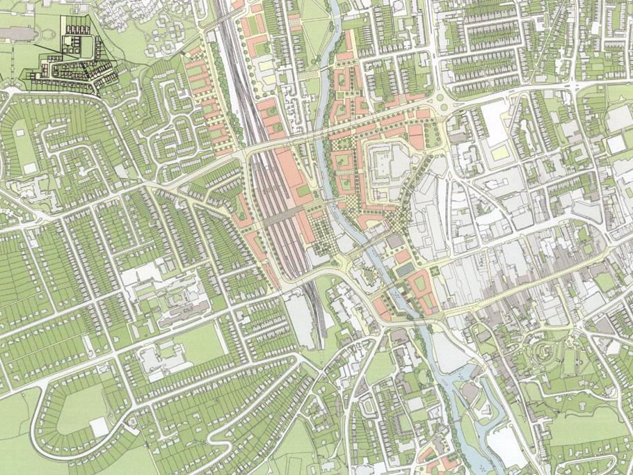
For hundreds of years, the river in Guildford has played a central role in the life, trade and development of the town and for the people who live, work and visit here.
In the last few decades, the town has been subject to poor planning, piecemeal development and policies that have put cars and buildings before people. Our town is divided by roads clogged with traffic. The riverside in the town centre must be opened up more, for both visitors and residents to enjoy.
To do this, there must be a new bridge across the river and railway, which will link east and west.
We propose a bridge that links Guildford Park Road with the York Road/Woodbridge Road roundabout, and that the Town Bridge (used for traffic until the 1960s) is then reopened to carry two lanes of vehicles. This takes traffic away from the town centre and means that the land around the river can become a six-acre riverside square, for leisure, pleasure, business and homes. It also means that the historic Guildford Town Wharf can be rediscovered, and that Bridge Street can become pedestrianised.
Preserve the Historic Town Core
More pedestrian-only space in the town centre
New public space, including squares and green space
Reinvigorated riverside
Redirection of traffic away from the town centre
An integrated transport hub for rail and road
More town-centre housing for all
A new, improved east-west link across the river
Our plan
GVG has worked with Leonard Design architects to prepare a visual masterplan for Guildford. The video and images below provide more detail on our proposals for improving the town centre.
The video fly-through provides an exciting 3D birds-eye view of what we’d like to see in Guildford, including open space, a beautiful riverside and traffic-free zones.
The system now
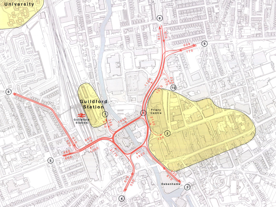
The current road system in Guildford is congested and polluted. There is lots of traffic in the town centre and it is difficult for walkers and cyclists to get around.
- Onslow Street
- North Street
- A281 Shalford Road
- A3100 Portsmouth Road
- A31 Farnham Road
- Guildford Park Road
- Walnut Treet Close
- A322 Woodbridge Road
- A246 York Road
- Leapale Road
# – # Combined average AM and PR peak hourly traffic to the nearest 10 vehicles per hour (8am to 9am and 5pm to 6pm) – figures from Sky High Traffic Survey dated 9th June 2011
Traffic redirected
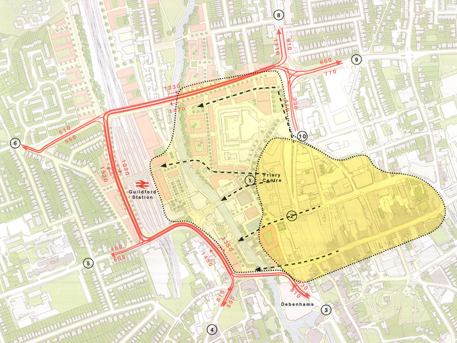
GVG would like to see traffic redirected from the centre of town, to create a more attractive, people-friendly destination. We would achieve this with a new corridor that crosses the railway to the north of the town centre.
This would mean better air quality, a thriving riverside and space for new market-style squares. New roads also mean an opportunity for better, safer routes for walkers and cyclists.
- Onslow Street
- North Street
- A281 Shalford Road
- A3100 Portsmouth Road
- A31 Farnham Road
- Guildford Park Road
- Walnut Treet Close
- A322 Woodbridge Road
- A246 York Road
- Leapale Road
# – # Combined average AM and PR peak hourly traffic to the nearest 10 vehicles per hour (8am to 9am and 5pm to 6pm) – figures from Sky High Traffic Survey dated 9th June 2011
New corridor
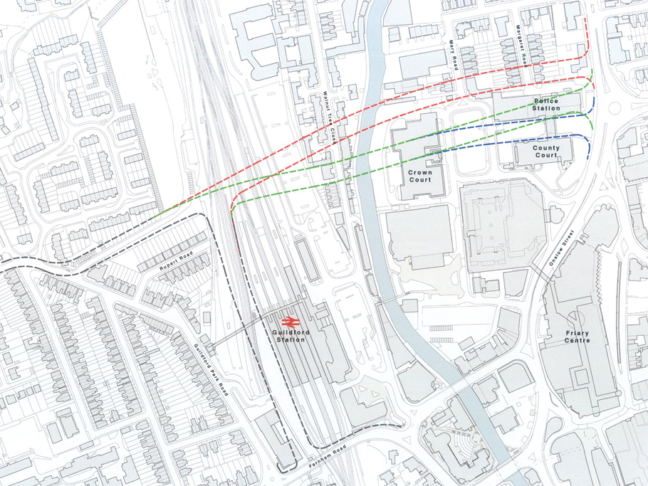
We think there are a number of options for a new corridor.
The red lines would avoid the police station and courts.
The green option would have the least impact on homes in the area, and would mean that the police station and courts need to be moved.
The blue option would put the crossing between the police station and the courts.
Facilities and services
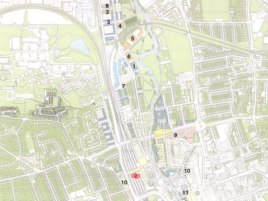
Recently, planning permission has been granted for new development at Guildford Station, which will make a difference to our full masterplan for the town centre. However, our plan for a corridor and changing the town centre will still include the following, with suggested locations marked on the plan:
- Retirement home
- Community centre
- Youth centre
- Sports club
- School
- Nursery school
- Medical centre
- GP surgery
- Police station, courts and government buildings
- Bus interchange
- Market
- Arts centre
Multi-purpose space
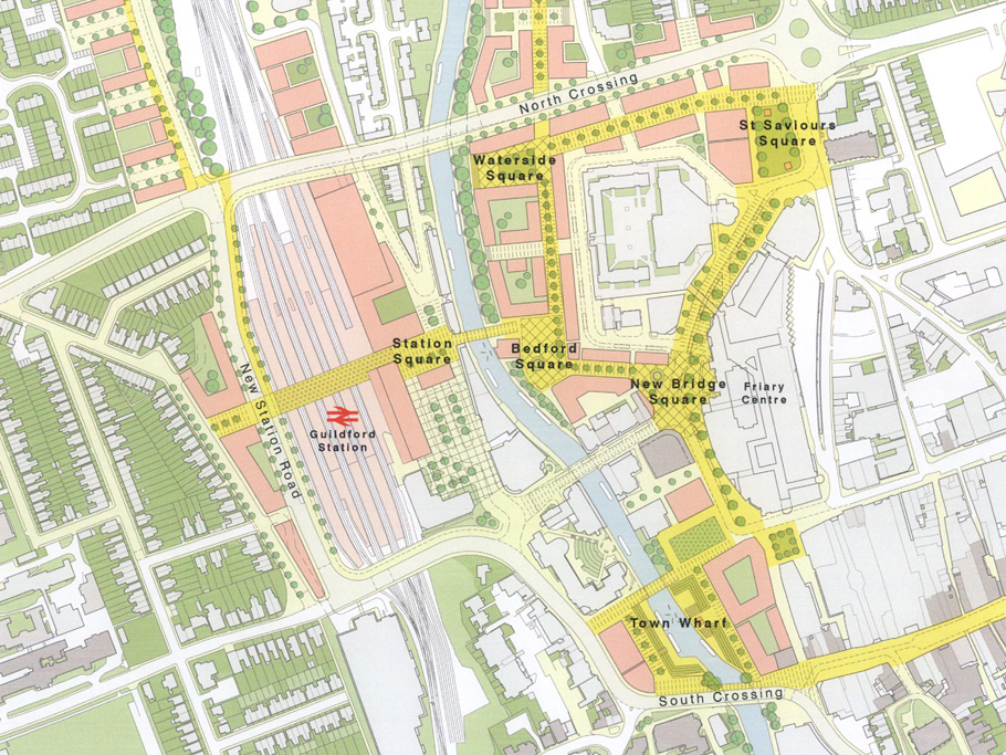
The masterplan proposes a number of new public spaces, which are connected by generous pedestrian boulevards. While their position may move as a result of planned works to the train station, they will still be incorporated:
The Town Wharf is a proposed multi-purpose space connecting North Street and the High Street to the river. It could incorporate landscaped waterside seating, markets, restaurants, an arts centre and shopping opportunities.
New Bridge Square will be a focal point for a traffic-free Onslow Street. It will connect The Friary and Bedford Wharf, and uses will include shopping and a bus interchange.
St Saviour’s Square will be a civic square adjacent to St Saviour’s church, with new civic buildings providing a gateway into Guildford. The area will include green space and a venue for formal ceremonies.
The Waterside will link Bedford Wharf and St Saviour’s Square. It can be used for office space, residential and outdoor dining.
Bedford Square could connect the station to the town centre and be a cultural hub. A hotel could be located here, as well as space for outdoor performances, screenings, restaurants and bars.

